Publishing

Urbanisation Dynamics in West Africa 1950–2010
Africapolis I, 2015 Update
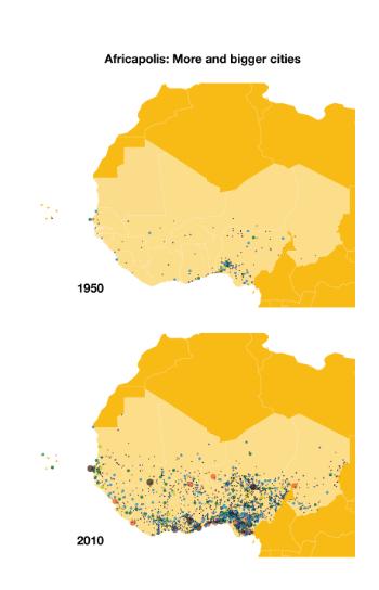
Since 1950, the number of urban agglomerations in West Africa increased from 152 to
almost 2 000, and today towns and cities are home to 41% of the region’s total population.
Cities and their inhabitants are increasingly shaping West Africa’s economic, political
and social landscape. Yet there is little up-to-date data available for analysis and
the formulation of development policy at the local, national and regional levels.
Africapolis, a comprehensive and homogenous dataset on urbanisation, is a significant
step towards closing this data gap. The 2015 update covers 17 West African countries
spanning the period 1950 to 2010. Its original methodology combines demographic sources,
satellite and aerial imagery to provide population estimates and geolocation at the
level of individual agglomerations. The morphological approach adopted by Africapolis
helps identify territorial transformation processes which are at the core of West
Africa’s complex urbanisation dynamics and can be observed at several levels: metropolises,
secondary cities, the merging of villages and the formation of conurbations.
The identification of cities with fewer than 100 000 inhabitants is a major contribution
of Africapolis – 90% of West Africa’s cities, or a combined population of 45 million
people, fall into this category – a figure which underscores the important role of
small cities within the urban system. This edition also includes new measurements
of urbanisation in Nigeria, Africa’s most populous nation, constituting the most complete
dataset on urbanisation dynamics in this country to date.
Published on March 18, 2016Also available in: French
In series:West African Studiesview more titles
TABLE OF CONTENTS
| Foreword | |
| The Sahel and West Africa Club | |
| The global e-Geopolis programme | |
| Executive summary | |
| Overview. Updating knowledge on urbanisation in West Africa | |
| Challenges in tracking change in West African settlement dynamics | |
| Demographic growth and the spread of agglomerations in West Africa | |
| Urban morphologies and new urban forms in West Africa | |
| Estimating the population of Nigerian cities |
Powered by OECD iLibrary