

Urbanisation Dynamics in West Africa 1950–2010
Africapolis I, 2015 Update
Published on March 18, 2016Also available in: French
In series:West African Studiesview more titles
TABLE OF CONTENTS
| Foreword | |
| The Sahel and West Africa Club | |
| The global e-Geopolis programme | |
| Executive summary | |
| Overview. Updating knowledge on urbanisation in West Africa | |
| Challenges in tracking change in West African settlement dynamics | |
| Demographic growth and the spread of agglomerations in West Africa | |
| Urban morphologies and new urban forms in West Africa | |
| Estimating the population of Nigerian cities |
THE 2015 UPDATE: A RE-SHAPED HUMAN, SOCIAL AND ECONOMIC GEOGRAPHY 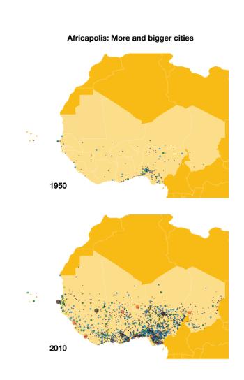
The 2015 Update identifies 1 947 urban agglomerations as of 2010 and the data allows to characterise and track the evolution and territorial transformation of old and new urban centres (population, location, distances between agglomerations, and morphology).
The data highlight the importance of small- and medium-sized agglomerations in national urban networks and the emergence of new urban agglomerations through in situ urbanisation.
The SWAC Secretariat worked with the e-Geopolis Project on the 2015 update of Africapolis which covers 17 West African countries spanning the period 1950 to 2010.
The Update provides:
- Systematic geolocation of urban agglomerations (with at least 10,000 inhabitants and less than 200 metres between buildings) broadening the analytical scope for mapping and spatial analysis;
- The identification of small cities (fewer than 100 000 inhabitants) that are not listed in any international database and which count for 90% of West Africa’s cities, or a combined population of 45 million people;
- Extensive and updated inventory of agglomerations in Nigeria, accounting for more than half of West Africa’s population.
FIND OUT MORE